Environment
Environment
23
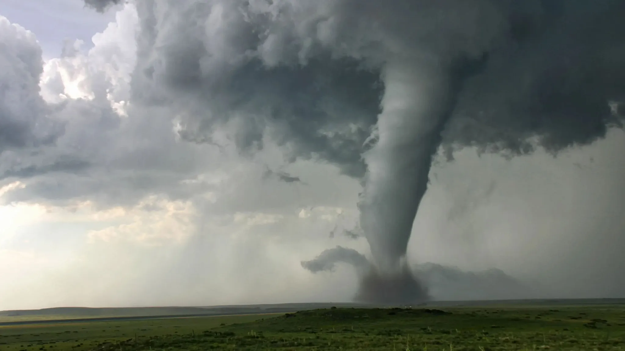
More Tornadoes, Fewer Meteorologists: America Faces the Climate Storm
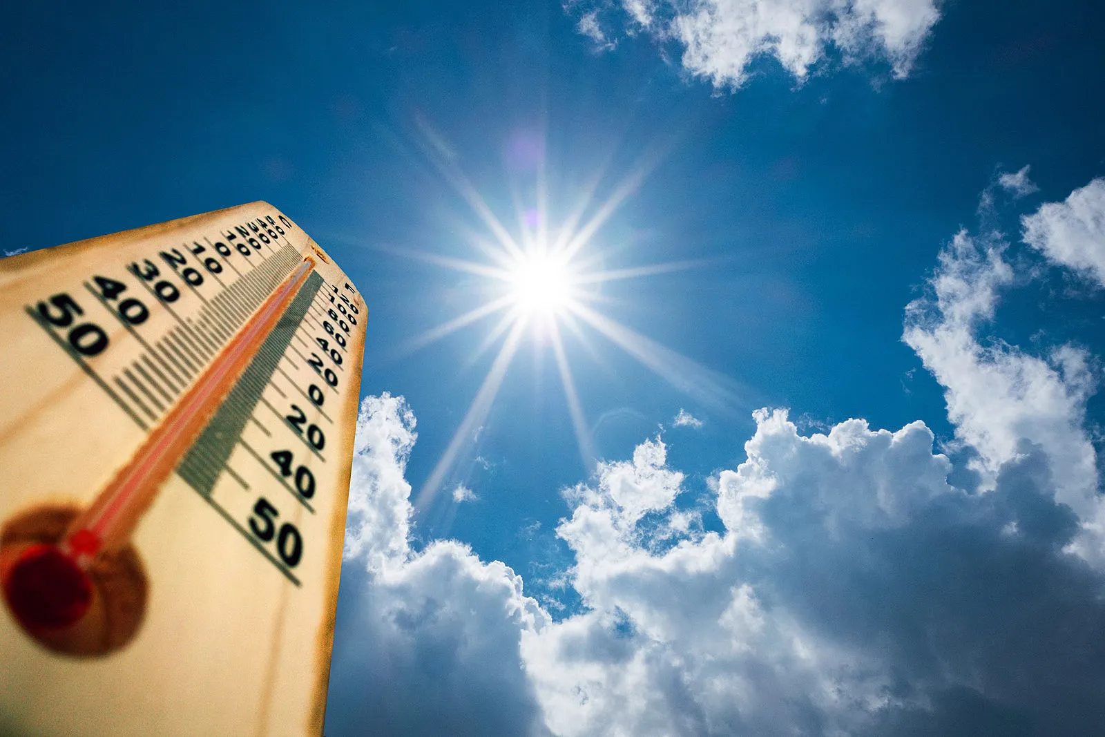
On Friday evening, as deadly tornadoes swept from Kansas to Kentucky, leaving behind a trail of 20 fatalities and thousands of destroyed homes, the National Weather Service (NWS) office in Jackson, Kentucky, was supposed to be closed. Budget cuts implemented by the Department of Efficiency under Elon Musk’s oversight forced the agency to save resources by closing offices after working hours. But that night, meteorologists worked tirelessly, desperately tracking storms threatening millions. This scene is not an exception but a warning sign: as the U.S. faces increasingly frequent tornadoes, a fatigued NWS is on the brink of its capabilities, causing concern among experts and officials.
Storms intensify, resources dwindle
2025 is already marked as one of the most active tornado seasons in U.S. history. The NWS Storm Prediction Center in Norman, Oklahoma, recorded 883 tornado reports as of May, which is 35% above the average for this time of year. Just over the weekend, storms hit Missouri, Arkansas, Oklahoma, and Texas, where the risk of new tornadoes on Tuesday was estimated at 10% for 10.6 million residents. But while nature tests America’s resilience, the NWS is fighting another crisis: staffing shortages.
Cutbacks initiated by the Trump administration have left key NWS offices critically understaffed. In Jackson, Kentucky, 25% of positions are vacant; in Louisville — 29%; in Wichita, Kansas — 32%. “We’re doing all we can, but it’s like trying to put out a fire with a half-empty bucket,” admits Rick Thompson, lead meteorologist at the Storm Prediction Center in Norman. His words reflect the reality of an agency that, despite technological advances, relies heavily on human expertise — meteorologists whose knowledge and vigilance save lives.
Exhaustion on the brink of catastrophe
Former NWS employees, many of whom were dismissed during previous cutbacks, paint a bleak picture. “They issue forecasts on time, but it’s all driven by sheer will,” says Albert “Joe” Friday, a former NWS director. “You can’t make people work 80 or 120 hours a week forever. Eventually, they’ll lose track of what they see on the radar.” Oklahoma University meteorology professor Howard Bluestain, who pursued six tornados on Sunday, adds: “If a station is understaffed, forecast quality suffers. It’s inevitable.”
In Jackson, where storms claimed nearly 20 lives, the office was able to operate only thanks to overtime shifts and support from neighboring units, says NWS spokeswoman Erica Graw Seah. But that is only a temporary solution. “We have duct tape, but the holes in the boat are multiplying,” says Tom DiLiberto, a laid-off meteorologist, comparing the situation to a sinking ship. According to insider information, some NWS offices operate with minimal staff, where one meteorologist simultaneously analyzes radar, issues warnings, and responds to local authorities — tasks previously distributed among several specialists.
Climate roulette: Why tornadoes are increasing
The rise in tornadoes is not accidental. Experts say that warmer air from the Mexican Gulf, with temperatures several degrees above normal this year, charges the atmosphere with moisture, creating ideal conditions for powerful storms. “It’s like adding fuel to an engine,” explains Bluestain, noting that the collision of moist air with cold fronts through jet streams produces stronger tornadoes. Ohio State University atmospheric sciences professor Yana Hauser adds that climate change makes the atmosphere unpredictable: “Some days it seems overcharged, and others it weakens.”
This year, tornadoes have been recorded earlier than usual in states such as Alabama, Georgia, and Mississippi, where winter months were previously too cold for such phenomena. But the connection between climate change and tornadoes remains complex. “We have a better understanding of how climate affects rain and heat, but tornadoes remain ambiguous,” admits Harold Brooks of the National Severe Storms Laboratory. However, one thing is clear: the population in risk zones is growing, along with potential losses.
Technology against human fatigue
Technological progress—from improved radar systems to satellite data—has made tornado forecasting more accurate. But, as Karen Kosiba, director of the FARM meteorological equipment network, points out, “Radar cannot replace the human interpreting data and deciding how to warn the community.” Budget cuts have also reduced launches of meteorological balloons that provide crucial atmospheric data and limited meteorologists’ field trips for training with local officials. “We are losing not only personnel but also connections with communities that depend on our warnings,” says Luis Uccellini, former NWS director.
In the so-called Tornado Alley — the region encompassing Texas, Oklahoma, Kansas, and Missouri — where tornadoes are part of life, resource shortages are felt especially acutely. Local offices such as Wichita or Jackson not only issue warnings but also coordinate actions with emergency services, which requires clarity and speed. “When 20% of positions are vacant, something inevitably slips through,” warns Uccellini.
Looking ahead: Risks that can be avoided
While the NWS struggles with staffing shortages, Americans in Tornado Alley prepare for new strikes. Governors of Missouri and Arkansas have already declared a state of emergency, and the National Guard is helping clear debris. But without proper funding and staffing, risks will grow. “It’s not a matter of if a disaster will happen, but when,” says Brooks, pointing to increasing urbanization in risk areas.
For communities relying on accurate forecasts, the cutbacks in the NWS are not just bureaucratic problems but threats to lives. In Norman, where meteorologists work in a modest office surrounded by fields, Thompson remains optimistic: “We will do everything in our power.” But his words sound like a call to action: America cannot afford to economize on those standing between storms and its people’s lives. In a world where climate becomes increasingly harsh, meteorologists are not just scientists but guardians whose vigilance determines whether we can avoid the next tragedy.
21.05.2025
Environment
28
Night Storm in Kuyahoga Falls: Tree Penetrates House, but Family Saved Miraculously
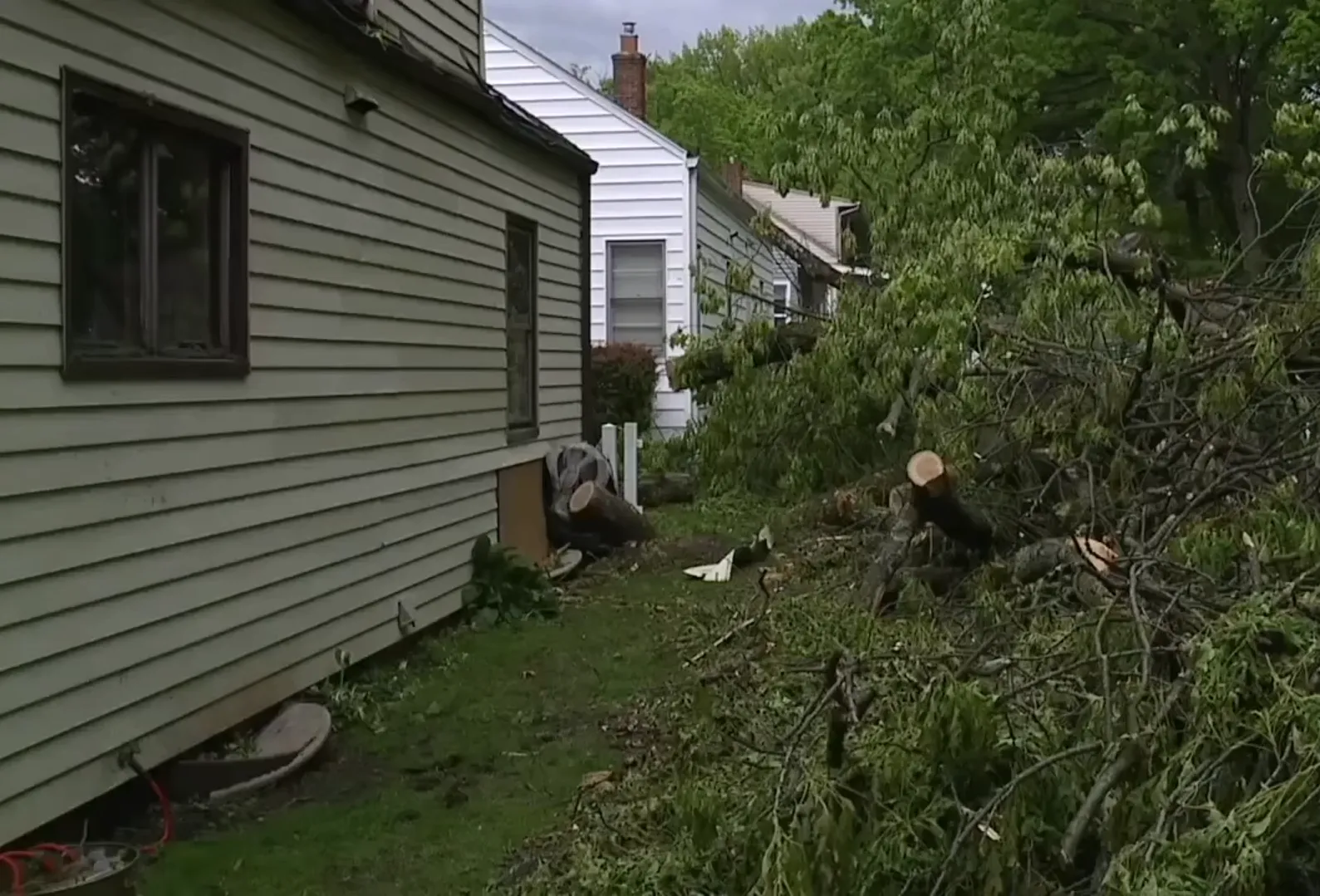
CUYAHOGA FALLS, Ohio — In the pre-dawn darkness, as a storm with a roar swept through Northeast Ohio, Brenda and Henry Ryan's house in Cuyahoga Falls became the arena of nature's fight with destiny. Around three in the morning, a huge tree from a neighbor's yard, torn out by the fierce wind, punched through their roof, leaving ten holes, shattered windows, and a broken air conditioner. But amid the debris and chaos, the Ryan couple gives thanks to the heavens for a miracle: their 14-year-old grandson, whose room was wrecked, was safe, and they themselves narrowly escaped tragedy. This night, which left tens of thousands of residents in the region without electricity, served as a reminder to the Ryan family of life's fragility and the power of gratitude.The storm that changed everythingThe storm, which hit the region with winds up to 70 miles per hour, left a trail of destruction: fallen trees, downed power lines, and thousands of households in darkness. In Cuyahoga Falls, a quiet suburb of Akron where cozy houses line green streets, no one was prepared for such a force of nature. For Henry Ryan, 68, a retiree, the moment when the tree broke through the roof was like an explosion. “I thought it was the end,” he recalls, voice trembling from the shock. “The wind howled, then—bang, like an explosion. I still marvel that my heart held up.”The fallen tree not only shattered the roof but also burst into their grandson's room, tossing his bed across the entire bedroom. “The branch went where his head should have been,” says Brenda Ryan, 65, with tears in her eyes. “If he had been home, I don't know if I would be talking to you now.” The boy, who was staying at a friend's place, narrowly escaped danger, but the scene in his room—cracked walls, scattered belongings—became a painful sight for Brenda. “It took me a few minutes to recover,” she adds.A miracle amid the debrisAmong the wreckage, Brenda saw a sign that brought her comfort. In her grandson's room, where everything was turned upside down, a crucifix and a photograph of his late mother remained untouched. “I believe she was protecting him,” Brenda says, her voice filled with quiet confidence. “There are things stronger than a storm.” For the couple who lost a daughter a few years ago, this moment became not just a coincidence but a symbol of hope.The Ryan family’s house, a modest two-story home where they raised children and hosted grandchildren, now needs serious repairs. The roof is leaky, the air conditioner is shattered, and windows across the house resemble a glass mosaic. “It's crazy how one tree can cause so much damage,” says Henry, inspecting the debris in the yard. “But we are alive, and that’s the main thing.” The insurance company is already assessing the damage, but Brenda fears that without air conditioning, summer will be unbearable. “We’ll survive,” she adds. “The most important thing is that we are together.”The community unitesThe community's response was immediate. Despite the chaos caused by the storm, the local fire department dispatched a contractor to the Ryan house, arriving at 3 a.m. “We were sitting at the dining table, drinking coffee and filling out paperwork,” Brenda recalls warmly. “In moments like these, you realize that neighbors are more than just people nearby.” The contractor temporarily covered the holes in the roof with a tarp, but full repairs are expected to take until July.Cuyahoga Falls, like the entire Northeast Ohio, awoke in a state of recovery. According to FirstEnergy, tens of thousands of customers in the region remain without power, and in Summit County, which includes Cuyahoga Falls, more than 20,000 households have experienced outages. Fallen trees blocked roads, and utility crews are working around the clock to restore the lights. “This isn’t our first storm, but it’s one of the worst,” says Mayor Don Walters, who is coordinating the relief efforts.Broader context: Climate and vulnerabilityThis storm is not just a natural whim, but part of a disturbing trend. According to the National Weather Service, extreme weather events in Ohio are becoming more frequent due to climate change, which intensifies thunderstorms and wind gusts. “We see more storms with such strength,” notes meteorologist James Crosby from Cleveland. “And communities like Cuyahoga Falls are not always prepared.” Insider information suggests that local authorities are considering investments in protective tree planting and upgrading the electrical grid, but budget limitations delay these plans.For the Ryans, the storm also revealed vulnerabilities in their home. “We never thought that a neighbor’s tree could be a threat,” says Henry. “But now we will reconsider everything.” The couple already plans to discuss with neighbors trimming old trees, and Brenda jokes that she might plant new ones, “but farther from the roof.”Life after the stormWhile repair crews assess the damage and insurance agents fill out forms, the Ryans are looking for ways to return to normal life. Their backyard, once a favorite spot for family barbecues, is now strewn with debris, and the bird feeders Brenda carefully filled are destroyed. “I’ll figure out how to feed my birds,” she says with a smile. “They count on me.”But behind their resilience lies a deeper truth: the storm left not only material losses but also emotional scars. “When you see your home, your refuge, falling apart in seconds, it changes you,” Brenda admits. “But we don’t give up.” Their story reflects the spirit of Cuyahoga Falls, a community that, despite the blows of nature, holds together, grateful for the miracles and preparing for new challenges.As Ohio recovers from the night storm, the Ryans remind everyone: in a world where nature can be merciless, the greatest strength is love, faith, and the ability to value what remains unbroken. Their house will be restored, but the memory of the guardian angel who saved their grandson will stay forever.
19.05.2025
Environment
19
Weather forecast: Monday, May 19, rain and wind return to Ohio
During the week from May 19 to 25, 2025, in Ohio, cool and unstable spring weather is expected. The beginning of the week will be mostly dry, but from Tuesday there may be short-term showers, and from Friday — . Temperatures will fluctuate from +17 °C to +22 °C, with nights remaining cool.Weekly forecast:Monday, May 19, is expected to be mostly sunny with no precipitation. Daytime temperatures will rise to +20 °C, and at night will drop to +10 °C. Tuesday, May 20, will retain clear weather with slight cloudiness. Temperatures during the day will reach +21 °C, and at night will fall to +11 °C.Wednesday, May 21, will be sunny in the morning, but in the afternoon clouds (cloudy) will appear with possible short-term showers. The maximum temperature will reach +22 °C, and at night will be around +12 °C.Thursday, May 22, is expected to be , especially in the second half of the day. Daytime temperatures will be +21 °C, and at night will decrease to +11 °C.Friday, May 23, forecasts variable cloudiness with periodic clearings. Daytime temperatures will rise to +20 °C, and at night will stay at +10 °C.Saturday, May 24, may have short-term showers and wind gusts up to 30 km/h. The maximum temperature will reach +19 °C, and at night around +9 °C.Sunday, May 25, will be mostly cloudy, with no significant precipitation. Daytime temperature will be +17 °C, and at night around +8 °C.Sunrise / sunset times on Monday:Sunrise: 6:05 AMSunset: 8:45 PMSummary forecast in brief:Monday: Mostly sunny. | Max temperature: +20 °CTuesday: Clear, slight cloudiness. | Max temperature: +21 °CWednesday: Cloudy, short-term showers. | Max temperature: +22 °CThursday: Rainy weather. | Max temperature: +21 °CFriday: Variable cloudiness. | Max temperature: +20 °CSaturday: Short-term showers, wind gusts. | Max temperature: +19 °CSunday: Cloudy, no precipitation. | Max temperature: +17 °CThroughout the week, cool and unstable spring weather is expected. The beginning of the week will be mostly dry, but from Tuesday, short-term showers may occur, and from Friday — thunderstorms and strong gusts of wind. It is recommended to plan outdoor activities for the early days of the week and to monitor updates to the forecast.
19.05.2025
Environment
38
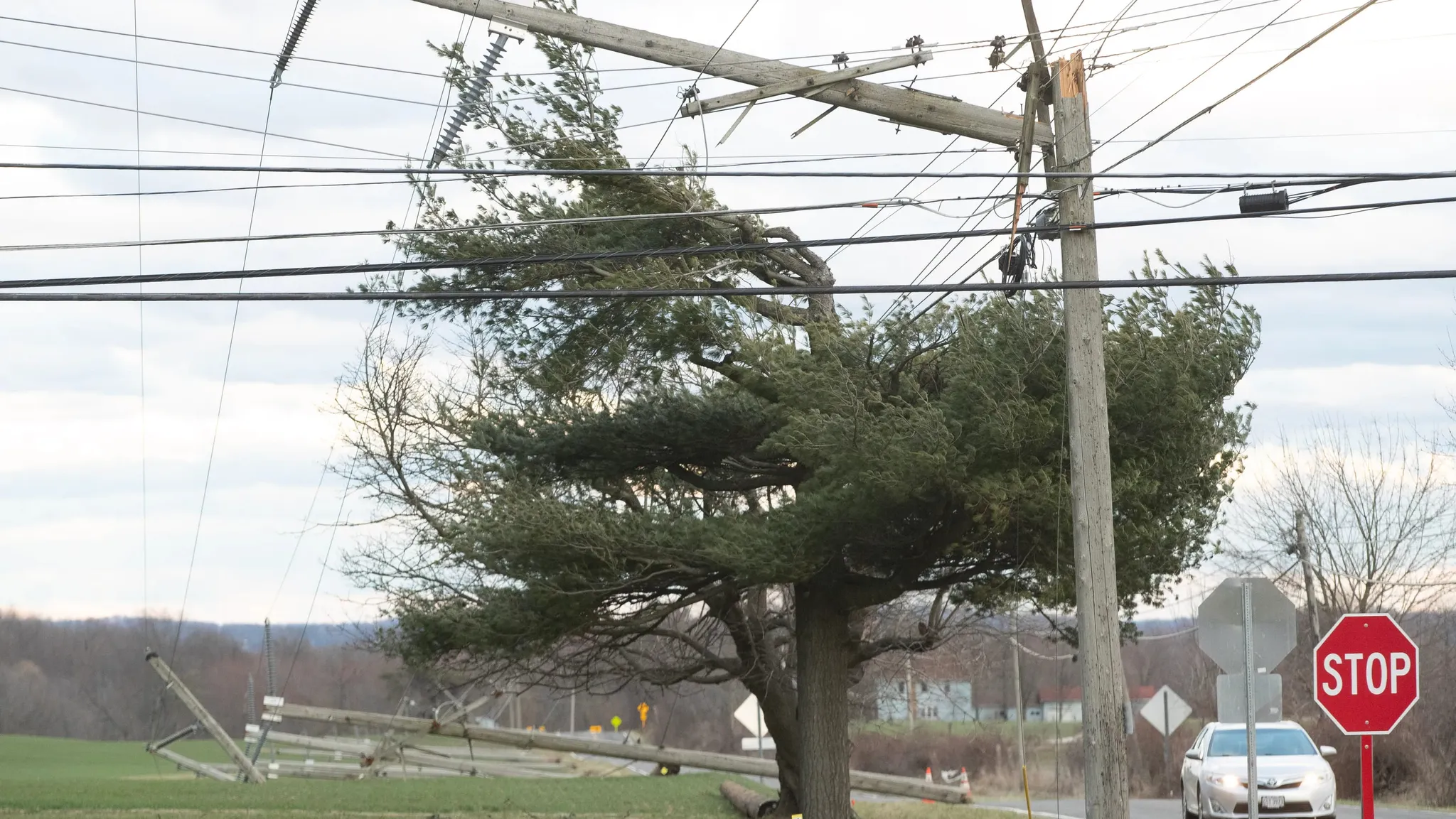
Storm paralyzes Northeast Ohio: Almost 80,000 residents without electricity
AKRON, Ohio — On Friday evening, a powerful thunderstorm swept through Northeastern Ohio, leaving darkness, fallen trees, and nearly 80,000 households without electricity. Summit County, the heart of the region, was hit hardest: 45,867 subscribers lost power, and the chaos caused by the storm is felt from Cleveland to rural corners of Wayne County. FirstEnergy, the region’s main electricity provider, is battling the aftermath, but for many residents, this night became a test of resilience amid natural fury.As of 12:35 Saturday, according to FirstEnergy, the scale of outages is staggering: 10,482 customers in Stark County, 7,896 in Portage, 4,014 in Wayne, 2,195 in Richland, 2,399 in Cuyahoga, 1,597 in Medina, and 1,210 in Lorain are still without power. A storm warning issued by the National Weather Service until 4:00 a.m. Saturday covered Stark, Mahoning, Medina, Summit, Trumbull, and Portage counties, warning of strong gusts, lightning, and possible local floods.Merciless StormThe storm, which came from the west, brought winds up to 70 miles per hour, ripping up trees and snapping power lines. In Akron, the largest city in Summit County, streets were covered with branches, and in some neighborhoods, debris blocked roads. “It was like something out of an apocalyptic movie,” says Linda Carter, a Canton resident whose house lost power after a transformer near her home exploded from a lightning strike. “Flashes, thunder, and then — darkness.”According to insider information, FirstEnergy has mobilized additional crews from neighboring states, but restoration may take time due to the scope of damage. “Some lines are literally torn apart,” a company source reported. “We are working around the clock, but in the most remote areas, people will have to wait until Sunday.” In Cuyahoga and Summit, where electricity has already been restored to thousands of subscribers, progress is noticeable, but in Stark and Portage, the situation remains critical.Communities in Darkness but Not Without HopeFor residents of Northeast Ohio, where harsh winters and sudden storms are not uncommon, power outages are a familiar trial. However, the scale of this storm’s impact has caused many to reassess their preparedness. In Barberton, a suburb of Akron, locals queued up for generators and batteries, while volunteers distributed water and blankets at community centers. “We’re sticking together,” says James Wilson, an organizer of aid in Stark County. “But going without light and heat in May — that’s no joke.”Akron Mayor Den Gorirgan urged residents to be patient, promising that the city is coordinating efforts with FirstEnergy and local rescue services. “This isn’t our first storm, and it won’t be the last,” he said at a press conference. “But we will get through this together.” Meanwhile, in Cleveland, where fewer people have been affected by outages, Cleveland Public Power has reported localized disruptions that are already being addressed.Climate and Infrastructure ChallengesThis storm is not just a natural disaster but a mirror of broader problems facing Ohio. Meteorologists say that severe thunderstorms are becoming more frequent due to climate change, which amplifies extreme weather events. At the same time, Ohio’s aging grid infrastructure, much of which was built in the mid-20th century, is increasingly strained. “We haven’t invested enough in modernization,” notes Eric White, an energy analyst from Cleveland. “Every new storm exposes that vulnerability.”Rumors circulate in local government circles about plans to upgrade the power grid, but budget constraints and political disagreements slow progress. “This isn’t a matter of a year or even a decade,” White adds. “But if we don’t start now, such outages will become our new normal.”Looking to the FutureWhile FirstEnergy crews clear fallen trees and tangled wires, Ohio residents demonstrate their characteristic resilience. In Canton, the school gym has been transformed into a temporary shelter where neighbors share food and stories. In Medina, volunteers deliver lanterns to the elderly. These small acts of solidarity serve as a reminder that even in the darkest times, a community can shine.But beyond these touching moments lies a harsh truth: Northeast Ohio, like many regions of America, is at a crossroads. Will this storm serve as a catalyst for change, or just another chapter in the ongoing struggle with nature and aging infrastructure? As residents recharge their flashlights and wait for power to return, the answer remains as uncertain as the May skies over Ohio.
17.05.2025

Environment
22
Akron Comes Alive: 1,800 Trees to Revitalize Neighborhoods and Uplift Community Spirit
AKRON, Ohio — This spring, Ohio's industrial heart beats to a new rhythm: the city of Akron has launched an ambitious campaign to plant 1,800 trees to revive its most vulnerable neighborhoods and restore a green soul to the urban landscape. Focused on the Kenmore, Summit Lake, and Eastern Akron areas, this initiative is not just about greening, but a strategic step to improve quality of life, increase property values, and combat environmental challenges. In a city where asphalt often dominates over nature, these trees represent hope for a greener, healthier, and more prosperous future.
Under the gentle spring sun, crews of arborists led by city arborist Matthew Knoll are transforming bare streets into green corridors. Lindsay Avenue, previously devoid of trees, is now adorned with young saplings, and oaks have appeared on Brooklands Drive at the request of local families. “We see a direct correlation: more trees — higher property values; fewer trees — lower,” explains Knoll, whose enthusiasm is contagious. According to him, neighborhoods with the lowest levels of tree cover, such as Kenmore or Eastern Akron, also have the lowest housing prices, and the city aims to address this inequality.
The project, funded from the city budget, offers homeowners free planting, care, and even removal of trees if necessary. Residents can request a tree via the 311 hotline, the website akronohio.gov/311, or a mobile app, choosing local varieties like northern red oak, serviceberry, or sugar maple. “We want people to feel involved,” Knoll says. “Some fear they will have to pay for a tree, but this is our gift to the city.” Residents such as Bill Lyons from Highland Square are delighted. “When we found out a oak would be planted on our lot, it felt like a gift from fate,” he shares, glad that the city chooses trees that are safe for sidewalks and streets.
Insider information suggests the initiative has deeper roots. City officials, concerned about ecological issues, aim not just to beautify streets but also to combat climate change. Data shows that Akron's trees have already absorbed 1.2 million pounds of pollutants and 70,113 tons of carbon dioxide, as well as retained 255 million gallons of stormwater, easing the burden on the sewer system. In areas where asphalt absorbs solar heat, trees reduce temperatures, making summer days more comfortable and lowering air conditioning costs.
However, not all residents support the project immediately. Some worry that trees will complicate lawn care or damage infrastructure. Knoll assures that the city carefully selects species and planting locations to prevent problems. “We’re not just planting trees; we’re building the future,” he says, dreaming of the day when Kenmore or Summit Lake will become green oases with a thriving economy.
For Akron, a city experiencing economic ups and downs, this initiative is more than just greening — it’s an investment in health, well-being, and community pride. Residents like Lyons see it as a sign: authorities are working for the people. “It’s not just about trees,” he says. “It’s hope for a better tomorrow.” As young saplings take root, Akron reminds everyone: even in America’s industrial heart, there’s room for a green miracle.
16.05.2025
Environment
16
Weather forecast: Monday, May 12, temperatures rapidly rising before rain returns
During the week from May 12 to May 18, 2025, in Ohio, variable spring weather is expected: the beginning of the week will be warm and dry, but from Wednesday onwards, short-term rains and thunderstorms are possible. Temperatures will fluctuate from +19 °C to +24 °C, with nights remaining moderately cool.Weekly forecast:On Monday, mainly sunny weather without precipitation is expected. Daytime temperatures will rise to +22 °C, and at night will decrease to +12 °C.Clear weather will continue on Tuesday, but with little cloudiness. Daytime temperature will reach +24 °C, and at night will drop to +13 °C. On Wednesday morning, it will be sunny, but in the second half of the day, clouds will appear, and short-term rains are possible. The maximum temperature will reach +23 °C, and at night it will be around +14 °C. Rainy weather is expected on Thursday, especially in the second half of the day. Daytime temperature will be +22 °C, and at night will decrease to +13 °C. Friday forecasts changeable cloudiness with periods of clear sky. Daytime temperature will rise to +21 °C, and at night will stay around +12 °C.On Saturday, short-term rains and gusts of wind up to 30 km/h are possible. The maximum temperature will reach +20 °C, and at night approximately +11 °C. Cloudy weather, without significant precipitation, will dominate on Sunday. Daytime temperature will be +19 °C, and at night around +10 °C.Sunrise / sunset times on Monday:Sunrise: 6:15 AMSunset: 8:37 PMSummary of forecast in brief:Monday: Mainly sunny. | Maximum temperature: +22 °CTuesday: Clear, slight cloudiness. | Maximum temperature: +24 °CWednesday: Cloudy, short-term rains. | Maximum temperature: +23 °CThursday: Rainy weather. | Maximum temperature: +22 °CFriday: Changeable cloudiness. | Maximum temperature: +21 °CSaturday: Short-term rains, gusts of wind. | Maximum temperature: +20 °CSunday: Cloudy, without precipitation. | Maximum temperature: +19 °CThroughout the week, warm and mostly sunny weather is expected initially, with gradual increase in cloudiness and the possibility of rain in the second half. It is recommended to plan outdoor activities for the early days of the week and to monitor weather updates.
12.05.2025
Environment
61
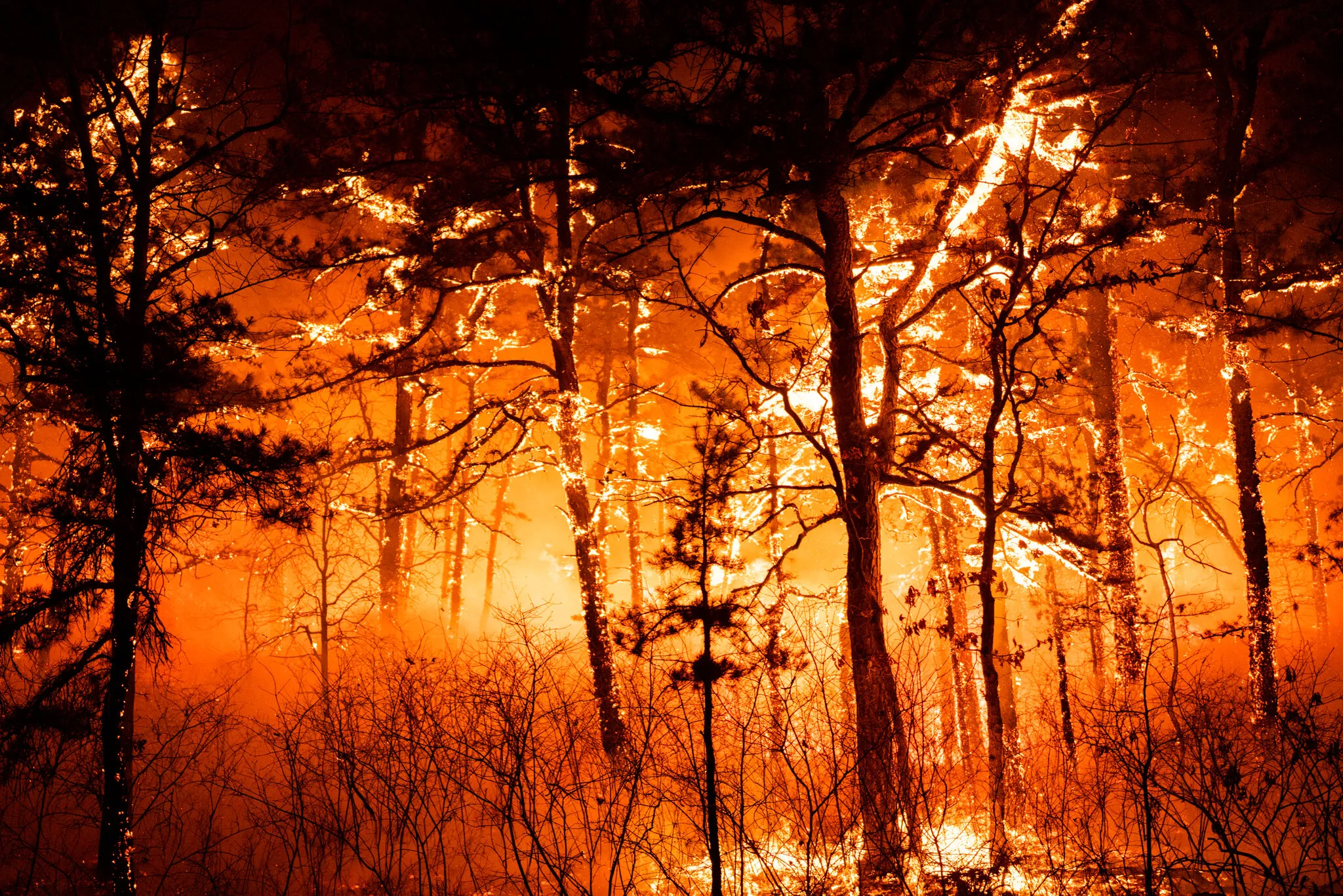
Second suspect arrested in connection with large forest fire on Jones Road in New Jersey
The storm that started with a spark continues to wreak havoc in southern New Jersey. State authorities announced on Friday the second arrest connected to the devastating forest fire that has covered over 15,000 acres in Forked River Mountains — and remains uncontrolled to this day.
According to prosecutors in Ocean County, a 17-year-old teen was detained on Thursday and charged with intentional arson, arson with aggravating circumstances, and obstruction of justice. His name has not been disclosed due to his age. This is the second defendant in the case, after 19-year-old Joseph Kling of Ocean City was last week charged with similar offenses.
According to investigation data, both young men allegedly set fire to wooden pallets and then left the scene without ensuring the fire was extinguished. The blaze rapidly got out of control, becoming one of the largest fires in the state in the past two decades — second only to the 2007 fire that destroyed over 17,000 acres.
At the time of publication, the fire was 80% contained; however, officials from the New Jersey Forest Fire Service emphasize that the threat has not passed. Due to strong winds and unstable weather conditions, there is a risk of rekindling.
"This is a crime with irreversible consequences," stated one state official, adding that despite the suspects' young age, "the consequences of their actions remain serious and long-lasting."
The fire led to the destruction of commercial property, the evacuation of over 5,000 residents, and the temporary closure of a key artery — Garden State Parkway. Energy company Jersey Central Power and Light reported power outages affecting over 25,000 consumers, which were later resolved.
While the justice system prepares for the next phase of court proceedings, ecologists and emergency responders are trying to assess the long-term impact of the event on the region's ecosystem, including wildlife and natural reserves that have fallen victim to the fire.
The hearing regarding the preventive measure for Joseph Kling, scheduled for Friday, was postponed to consider new details that emerged following the second arrest.
According to officials, this incident should serve as a painful reminder of the fragility of forest landscapes and the responsibility borne by every citizen, regardless of age.
08.05.2025

Environment
39
Weather forecast: Monday, May 5, evening expected continued showers
During the week from May 5 to 11, 2025, in Ohio, warm spring-like temperatures and predominantly sunny weather are expected. In the first half of the week, brief showers are possible, but from Thursday onward, clear skies with comfortable temperatures up to +24 °C will prevail. Nights will remain moderately cool.
Weekly forecast:
On Monday, variable cloudiness with light rain is expected in the afternoon. Daytime temperatures will rise to +20 °C, and nighttime temperatures will drop to +11 °C.
On Tuesday, cloudy weather with periodic clearing will persist. Local showers are possible in the second half of the day. The maximum temperature will be +19 °C, and at night – around +10 °C. On Wednesday, the sky will clear, and the weather will be dry and sunny. Daytime temperature will reach +21 °C, with +9 °C expected at night. Thursday will be warm and rainless. A light southern wind and temperatures up to +22 °C during the day, and up to +11 °C at night. On Friday, warm and sunny weather is forecasted. The maximum temperature will rise to +23 °C, and at night – +12 °C.
On Saturday, May 10, sunny weather with slight cloudiness will continue. Daytime temperature will reach +24 °C, and at night – +13 °C. On Sunday, May 11, the sky will be clear with no precipitation. Daytime temperature – up to +24 °C, and at night – +13 °C.
Sunrise / sunset on Monday:
Sunrise: 6:23 AM
Sunset: 8:29 PM
Summary forecast in brief:
Monday: Variable cloudiness, light rain. | Maximum temperature: +20 °CTuesday: Cloudy, local showers. | Maximum temperature: +19 °CWednesday: Sunny. | Maximum temperature: +21 °CThursday: Clear, no precipitation. | Maximum temperature: +22 °CFriday: Sunny. | Maximum temperature: +23 °CSaturday: Clear, slight cloudiness. | Maximum temperature: +24 °CSunday: Clear, no precipitation. | Maximum temperature: +24 °C
Throughout the week, stable spring weather with gradual warming is expected. In the first half, short rains may occur; however, clear skies will dominate later. It is recommended to plan outdoor activities and stay tuned for updated forecasts.
06.05.2025

Environment
45
Illinois breathes a sigh of relief: cicadas will bypass the state this summer
After the unprecedented rustling of summer 2024, when massive swarms of cicadas flooded orchards, parks, and yards in Illinois, residents of the state naturally ask: will the buzzing guests return this year?Experts provide a cautiously reassuring answer: for Illinois — most likely not. But neighboring regions in the Midwest, including Indiana, should prepare for a new invasion.According to the University of Connecticut, an interactive map tracking the appearance of periodical cicadas indicates that this summer will feature the emergence of the so-called Brood XIV — the second-largest periodical cicada brood in North America. Its range mostly covers southern Indiana, including the area around Huzier National Forest, and crosses into Kentucky.On the real-time updating map, bright icons mark locations where the first individuals have been observed, while red contour circles indicate potential areas of their appearance.Population outbreaks are also expected to affect other states — from Ohio to Missouri and further southeast. Compared to the extravagance of last year in Illinois, this invasion will be localized, but no less impressive for those who encounter it.Periodical cicadas, known for their mysterious biology, emerge from underground every 13 or 17 years, depending on the species, and synchronously fill the space with a loud chorus that can reach 100 decibels — louder than a lawnmower or the roar of an airplane on a runway.Last summer, Illinois became the stage of a unique natural spectacle: for the first time in over two centuries, Broods XIX and XIII coincided, creating a rare "double invasion" seen only in specific regions of the state.Although this year Illinois is likely to miss a large debut, scientists warn that in 2037, the state can again expect a major wave of broods.Meanwhile, for curious residents of the South or Midwest, the university map remains an indispensable guide for those who want to observe one of the oldest natural rituals — the emergence of insects that have spent years hiding in silence beneath our feet.
02.05.2025